Blog > Seller Guide > General
How to Check Flood-Prone Areas in the Philippines: Official Resources for Car Owners

Illustrative car owner checking information before a trip; no actual map or live warning is shown.
To check whether a location may be exposed to flooding, start with an official hazard resource such as HazardHunterPH or UP NOAH. Then check current PAGASA information and your local government’s instructions. A hazard map, a weather warning and a road-closure notice answer different questions.
This guide helps car owners choose the right source and interpret it carefully. It does not rank provinces or declare any address, parking area or route flood-free.
Hazard maps and current warnings are different
A hazard map describes susceptibility or a modelled scenario for an area. Its meaning depends on the source, layer, scale and assumptions. A current warning describes an evolving situation within its stated area and time. Neither automatically tells you whether a particular road is passable now.
HazardHunterPH’s own disclaimers acknowledge data, location and mapping limitations. Treat a low-hazard result as information to consider, not permission to ignore weather warnings, visible flooding or local instructions. An unshaded area can require further checking; do not assume that missing coverage means no hazard.
1. HazardHunterPH: check a specific location
HazardHunterPH generates indicative hazard assessments for a selected location. It is part of GeoRiskPH, a multi-agency initiative led by DOST-PHIVOLCS. The platform identifies the contributing agencies; for example, its flood-susceptibility information includes DENR-MGB data.
Check the location carefully and read the flood layer, legend and accompanying explanation. Keep the relevant source and report details with any notes you make. Do not apply one point’s result to an entire city or assume that a nearby parking entrance has identical exposure.
For an official assessment rather than a reference result, follow the agency route explained on the About HazardHunterPH page. The generated information is not a road-clearance certificate.
2. UP NOAH: explore hazard information around a location
UP NOAH is the University of the Philippines’ hazard-information resource. UP’s published explanation describes location-based flood, landslide and storm-surge information, with more detailed mapping available through NOAH Studio.
Read the selected layer and its scenario or legend before drawing a conclusion. Different layers answer different questions; flood susceptibility and storm surge are not interchangeable. If the map does not load on your device, do not interpret the blank screen as a safe result. Use another official source and ask your local disaster risk reduction office for guidance.
3. PAGASA: check flood information and current warnings
PAGASA’s Flood Information page brings together river-basin information, general flood advisories, Metro Manila monitoring and dam information. Before relying on a bulletin, check its issue time, affected area and instructions. Open the relevant item rather than relying on an old screenshot forwarded in a group chat.
Use PAGASA’s official warning explanations to understand the product you are reading. Rainfall warnings, river-basin bulletins and storm-surge information have different purposes; a colour or label should be interpreted using that product’s own legend.
PAGASA also provides a Flood Hazard Map directory. Use it for the available mapping resources, while keeping current warnings and local road conditions as separate checks.
4. LiPAD: find flood-map and LiDAR resources
LiPAD distributes data from the DOST-supported Phil-LiDAR programmes involving UP and partner institutions. Its landing page directs users to the Flood Map Catalog for flood-hazard maps and explains how other data requests are handled.
The portal currently carries a maintenance notice, so follow its published access instructions and confirm that the map for your area is available. Check the dataset’s date, coverage, scenario and use conditions. A research map is useful for planning; it is not a live road report or an automatic substitute for an official assessment.
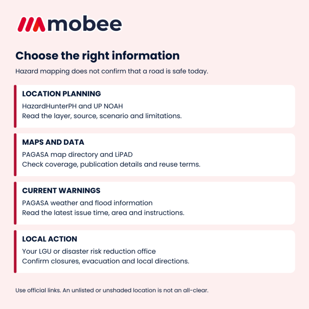
Use planning maps, current warnings and local directions together. Each serves a different purpose.
A practical location-checking routine
- Identify the exact place: check the address, map pin and nearby landmarks. Consider the parking entrance and access roads as well as the destination.
- Identify the information: note the agency, layer, scenario, legend and available publication or update date.
- Record questions: if coverage is missing or sources appear inconsistent, ask the relevant agency or local disaster risk reduction office to explain.
- Check current conditions: consult the latest relevant PAGASA bulletin and official local advisories before travel, and recheck when conditions change.
- Make a plan early: identify suitable alternatives for travel or parking while conditions remain safe, and follow local evacuation instructions when issued.
Keep official links and local emergency contacts accessible. If saving a map or bulletin for personal reference, retain its source, date and legend; an undated crop can lose the context needed to interpret it.
What this means for car owners
Do not drive through flooded roads to test a route or rescue a vehicle. Quezon City’s official flood guide, for example, tells residents to avoid walking or driving through flooded areas and to follow local evacuation protocols. Follow the instructions for your own locality; protecting a car must not delay getting people to safety.
Plan parking changes before a storm or rising water makes movement unsafe. Confirm access and permission with the parking operator; a building label or map colour is not a guarantee of safety. If you are already facing flood conditions, use our flood-season safety guide and the instructions of local authorities.
A location’s hazard classification also does not establish whether a particular used car has been flooded. For that question, examine its history and seek a professional assessment. Our flood-damage warning-sign guide explains the limits of visible clues.
Frequently asked questions
Is a list of flood-prone provinces enough?
No. It cannot describe every street, property or event. Check the specific location and current situation rather than assuming that an unlisted province is safe.
Can I use a map to decide that a flooded road is safe to cross?
No. A planning map does not measure the conditions in front of you. Avoid flooded roads and follow current official directions.
What if the maps disagree or a page will not load?
Check whether you selected the same location, hazard and scenario. Note the sources and dates, then seek clarification from the relevant agency or local office. A technical error is not a hazard assessment.
Should I reuse an old saved warning?
Use it only as a dated record. For a current decision, open the official source and read the latest relevant bulletin, including its area, issue time and instructions.
When you are ready to sell your car
Share your vehicle details and any known flood exposure with Mobee Cars Philippines. Mobee offers free inspection, no seller fees and access to 300+ verified used-car dealers, with offers arriving within hours after inspection. Ask the team about availability for your location and vehicle; this guide does not promise nationwide inspection coverage or acceptance of every flood-affected car.
Submit your vehicle details or use our official contact page. You can also call +63 960 399 9990.
Resource information checked on 27 October 2026. This is a planning-resource guide, not a current weather bulletin, location-specific assessment or guarantee of safety.
Was this article helpful?
How to Spot a Fake ORCR in the Philippines
17 April 2025 Mobee Cars PhilippinesVoluntarily Surrendering a Car to the Bank in the Philippines: What to Check First
17 May 2025 Mobee Cars PhilippinesHow to Sell a Financed Car in the Philippines Safely and Avoid Pasalo Scams
27 February 2025 Mobee Cars PhilippinesNo comment yet. Be the first to comment.